
Hurricane Dorian Public Advisory #23
Issued at 1100 PM AST Thu Aug 29 2019
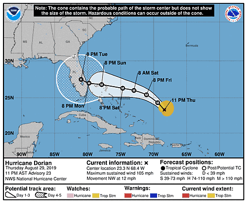
Location: 23.3°N 68.4°W
Max sustained: 105 mph
Moving: NW at 12 mph
Min pressure: 977 mb
000
WTNT35 KNHC 300254
TCPAT5

BULLETIN
Hurricane Dorian Advisory Number  23
NWS National Hurricane Center Miami FL       AL052019
1100 PM AST Thu Aug 29 2019

...HURRICANE HUNTER AIRCRAFT FIND A STRENGTHENING DORIAN...


SUMMARY OF 1100 PM AST...0300 UTC...INFORMATION
-----------------------------------------------
LOCATION...23.3N 68.4W
ABOUT 295 MI...470 KM ENE OF THE SOUTHEASTERN BAHAMAS
ABOUT 580 MI...930 KM E OF THE NORTHWESTERN BAHAMAS
MAXIMUM SUSTAINED WINDS...105 MPH...165 KM/H
PRESENT MOVEMENT...NW OR 325 DEGREES AT 12 MPH...19 KM/H
MINIMUM CENTRAL PRESSURE...977 MB...28.85 INCHES


WATCHES AND WARNINGS
--------------------
There are no coastal watches or warnings in effect.

Interests in the northwestern and central Bahamas should monitor the
progress of Dorian.  Watches may be required for portions of this
area on Friday.


DISCUSSION AND OUTLOOK
----------------------
At 1100 PM AST (0300 UTC), the center of Hurricane Dorian was
located near latitude 23.3 North, longitude 68.4 West. Dorian is
moving toward the northwest near 12 mph (19 km/h), and this general
motion is expected to continue through Friday.  A west-northwestward
to westward motion is forecast to begin by Friday night and continue
into the weekend.  On this track, Dorian should move over the
Atlantic well east of the southeastern and central Bahamas tonight
and on Friday, approach the northwestern Bahamas Saturday, and move
near or over portions of the northwest Bahamas on Sunday.

Maximum sustained winds have increased to near 105 mph (165 km/h)
with higher gusts.  Dorian is expected to become a major hurricane
on Friday and remain an extremely dangerous hurricane through the
weekend.

Hurricane-force winds extend outward up to 25 miles (35 km) from the
center, and tropical-storm-force winds extend outward up to 105
miles (165 km).

The latest minimum central pressure estimated from Hurricane Hunter
data is 977 mb (28.85 inches).


HAZARDS AFFECTING LAND
----------------------
RAINFALL:  Dorian is expected to produce the following rainfall
accumulations this weekend into early next week:

The central Bahamas...1 to 2 inches, isolated 4 inches.
The northwestern Bahamas...3 to 5 inches, isolated 7 inches.
Coastal sections of the Southeast United States...5 to 10 inches,
isolated 15 inches.

This rainfall may cause life-threatening flash floods.

SURF:  Swells are likely to begin affecting the east-facing shores
of the Bahamas and the southeastern United States coast during the
next few days.  These swells are likely to cause life-threatening
surf and rip current conditions.  Please consult products from your
local weather office.


NEXT ADVISORY
-------------
Next complete advisory at 500 AM AST.

$$
Forecaster Blake